Exhibitors 2019
- 3D PRINTING
- ART
- EDUCATION
- HOME AUTOMATION
- INTERNET OF THINGS
- KIDS & EDUCATION
- RECYCLING & UPCYCLING
- ROBOTICS
- SCIENCE
- YOUNG MAKERS (< 18)
- BIOLOGY
- GAMES
- ARTIFICIAL INTELLIGENCE
- OPEN SOURCE
- NEW MANUFACTURING
- FABRICATION
- WELLNESS & HEALTHCARE
- ENERGY & SUSTAINABILITY
- FOOD & AGRICULTURE
- 3D SCANNING
- CULTURAL HERITAGE
- AEROSPACE
- HACKS
- MUSIC & SOUND
- ARTISANS & NEW CRAFT
- FASHION & WEARABLES
- DRONES
- STEAM PUNK
- ARDUINO
- CROWDFUNDING
CNR4All Open Big Data and Precision Agriculture - AgroSat
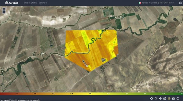
AgroSat combines digital technologies (IoT and Big Data) and scientific research products to create a collaboration platform that allows end-users to access, share, consult data – info – knowledge and plan actions. AgroSat is a full free open source platform and works from any web-browser and devices.
AgroSat provides the easiest and richest user experience in accessing satellite data, testing new analysis approaches for multi-source data integration, supporting the participatory approach to agro-environmental monitoring. It is primarily used to monitor field data through Earth Observation satellites, programming distribution of chemicals and knowing the location and cause of crop-stress to optimize quantities applied. It is a great platform that saves farmers both time and money.
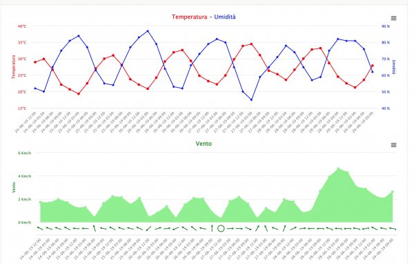
Users can manage multi farming unit, view 5 days weather forecast and local weather observation for their units. They can also report on their agronomic techniques, accessing a block chain geo-traceability service for supply chain. Users can be notified about new rules and sudden changes in crop condition and weather.
Italy
Piero Toscano, Leandro Rocchi, Riccardo Dainelli, Alessandro Matese, S. Filippo Di Gennaro
Leandro Rocchi
DSE – Diploma in Informatics Industrial Engineer
Research Technician at CNR-IBE, Institute of BioEconomy of National Research Council. Geoinformatics expert and developer of Agro-meteorological Spatial Data Infrastructures, WebServices, Enterprise applications, Models engineering and Mobile solutions.
Research Fields:
GeoScience studies applied in Agro-meterological and Environmental monitoring contexts following international standard and techniques as the Open Geospatial Consortium guidelines or the Open Innovation approach.
Riccardo Dainelli is an agronomist and research fellow at the National Research Council -Institute for Bioeconomy - in Florence (Italy). His research focuses on precision agriculture and in particular on remote sensing with field surveys and data processing on crops such as cereals, grapevine, vegetables and chestnut. In the recent past, he dealt with the environmental impact of crops using Life Cycle Assessment.
Riccardo Dainelli è agronomo e ricercatore post-doc presso l’Istituto per la Bioeconomia del CNR di Firenze. Si occupa di agricoltura di precisione e in particolare di remote sensing attraverso rilievi in campo ed elaborazione dati su colture come cereali, vite, ortive e castagno. In passato si è occupato d’impatto ambientale delle colture agrarie usando la metodologia Life Cycle Assessment.
B1 (pav. 7)


